


After record-breaking heat hit B.C. in late June, it appears the wildfire season has started.

There are now six wildfires of note burning around B.C., with many starting due to the tinder-dry conditions and lack of recent precipitation.
Forty-one active fires are burning in the province with 26 started in the last two days.
Map of wildfires burning around B.C.
Zoom into and move around the map above to see the location of the wildfires in B.C.
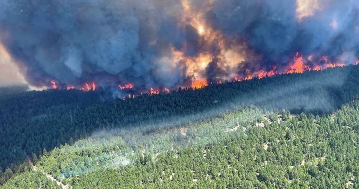
George Road Wildfire
Officials ordered the evacuation of the community of Lytton, B.C., Wednesday evening, just one day after the village shattered the record for the highest temperature ever recorded in Canada for three consecutive days.
It came as the 350-hectare George Road fire swept towards the community.
It is burning approximately seven kilometres south of Lytton, adjacent to Highway 1.
This fire is suspected to be human-caused but is still under investigation.

A unit crew working on the George Road wildfire.
BC Wildfire Service
McKay Creek
This wildfire is burning 23 kilometers north of Lillooet, along West Pavilion Road.
It is now an estimated 5,000 hectares and classified as out of control.
Smoke is visible from Lillooet and nearby areas.
The Squamish-Lillooet Regional District has issued an evacuation order for the West Pavilion road from the 14 kilometre mark to the 41 kilometre mark in Electoral Area “B.” Contact the Squamish- Lillooet Regional District for more information.
This fire is suspected to be human-caused but is still under investigation.
Read more:
Expert warns of ‘extreme fire danger’ as heat wave pushes B.C. wildfire risk to dangerous levels
Sparks Lake
This wildfire is burning 15 kilometres north of Kamloops Lake.
It is now an estimated 4,000 hectares and classified as out of control.
Smoke is visible from Kamloops and nearby communities.
The Thompson-Nicola Regional District (TNRD) has issued an evacuation order for 18 properties in Electoral Area “J” (Copper Desert Country).
There is also an evacuation alert for 150 properties in the Deadman, Red Lake, Tranquille Valley and Vidette Lake areas, as well as 298 addressed properties in the Loon Lake and Hihium Lake areas within Electoral Areas “E” and “J.”
This fire is suspected to be human-caused but is still under investigation.

Prince George Fire Centre
Beatton River
Discovered June 28, this wildfire is burning at Beatton River, a tributary of the Peace River.
It is an estimated 2,200 hectares in size and classified as out of control.
It is suspected to be caused by lightning but is not threatening any communities at this time.

G80997
This wildfire, burning north of the Buckinghorse River, adjacent to Highway 97 North in the Pink Mountain area, has not yet been named.
It is an estimated 4,800 hectares and classified as out of control.
It has prompted an evacuation alert for the following areas:
Peace River Regional District Electoral Area B
- 1.5 kilometres on either side of Highway 97N south of Mile 202 to Mile 190
- 5 kilometres west of Highway 97N and 25 kilometres east of Highway 97N from Mile 190 south to the Buckinghorse River Bridge on either side of the Alaska Highway 97N
- Minaker River Regional Park
Read more:
Soaring temps push western wildfire risk into ‘extremely extreme’ uncharted territory: experts

G91020
This wildfire, which has also not yet been named, is located along the Alaska Highway and is an estimated 2,200 hectares in size.
It is classified as out of control and is suspected to have been caused by lightning.
Drivers can expect delays due to the current closure of Highway 97N, which is closed in both directions between Sikanni Chief Road and Prophet River Sub Road for 59.3 kilometres (112 kilometres north of Wonowon to 114 kilometres south of Fort Nelson). The B.C. Wildfire Service and RCMP are on-site and will pilot essential traffic through when it is safe to do so.
© 2021 Global News, a division of Corus Entertainment Inc.
More Stories
Trump allies Meadows, Giuliani among 18 indicted in Arizona election interference case | CBC News
RCMP confirm 2 kayakers missing from Sidney, B.C., found dead in Washington state | CBC News
Why did the U.S. TikTok ban bill get packaged with foreign aid?